Welcome to the new home of Plan-G.
We are endeavouring to bring the old forum data across to the new one, but you will need to re-register here.Old forum archive: https://plan-g.app/oldforum/index.php
Plan-G v4
Plan-G is the multiple-award winning free flight planning tool for Microsoft Flight Simulator, X-Plane, and Prepar3D. Use it to create flight plans, which you can then save to disk and use in the simulator of your choice for your aircraft to follow. It requires Windows 8.1 or later.
Plan-G has the VFR pilot in mind. VFR - Visual Flight Rules is all about navigating by visual means. That doesn't just mean flying in good weather (although that's nice, particularly with the detailed scenery in modern simulators), but also using the particular skill sets of navigating by pilotage (reference to fixed features on the ground) and dead reckoning (calculating your position based on time, speed and heading. "Dead" is an old word for absolute or exact, as in "dead ahead" or "top dead centre" in an engine).
Of course no one can control the weather (okay, in a simulator you can, but...) and you may find yourself socked in with no hope of seeing the the airport, or the ground, or maybe even the end of your wing. And so Plan-G has a full suite of IFR tools, from instrument approaches to SIDs and STARs.
Please note: the availability of some features may depend on the simulator you are using, and the addons you have installed.
Features
Download here
Please consider a donation to help keep Plan-G going.
| Plan your Flight | Fly your Flight | Record your Flight |
|---|---|---|
 |
 |
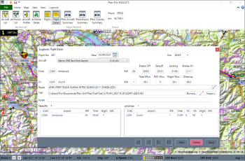 |
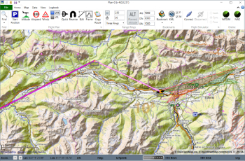
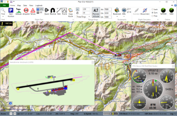
| Planning your flight is easy, quick, and fun, with our map-based UI. IFR flights can choose approach procedures, and also SIDs/STARs (MSFS and X-Plane11). Then export the plan to your simulator. | Connect Plan-G to your simulator , and follow your flight on the moving map. Airport charts show your position and also AI aircraft. Load nav frequencies to your radios by clicking them on the map. | Plan-G's all-new logbook keeps track of all your flights. Multiple reports will show how many hour and miles you've flown, which airports you've visited - and how often - and even where you left your plane, |
Plan-G has the VFR pilot in mind. VFR - Visual Flight Rules is all about navigating by visual means. That doesn't just mean flying in good weather (although that's nice, particularly with the detailed scenery in modern simulators), but also using the particular skill sets of navigating by pilotage (reference to fixed features on the ground) and dead reckoning (calculating your position based on time, speed and heading. "Dead" is an old word for absolute or exact, as in "dead ahead" or "top dead centre" in an engine).
Of course no one can control the weather (okay, in a simulator you can, but...) and you may find yourself socked in with no hope of seeing the the airport, or the ground, or maybe even the end of your wing. And so Plan-G has a full suite of IFR tools, from instrument approaches to SIDs and STARs.
Please note: the availability of some features may depend on the simulator you are using, and the addons you have installed.
Features
- Multiple Award Winning
- Runs on Windows 8.1 or later
- Simply unzip and run – no installation required
- OpenStreetMaps interface with 8 map styles including Bing Maps Aerial and Terrain
- Support for X-Plane 9, 10, 11, 12
- Support for Prepar3D 3, 4, 5
- Support for FS9, FSX, FSX SE, MSFS
- METARs and Winds Aloft
- Insert Snippet files and QuickSnippets into a plan
- Show multiple VOR & NDB radials
- Local KML & KMZ file support
- IFR departure, STAR and approach procedures where supported by the sim
- Support for Navigraph procedures within MSFS (requires MSFS Navigraph subscription)
- Aircraft performance profiles
- PFD and Fuel panel with aircraft-specific details
- Full logbook of flights, with many reports
- PDF chart viewer
- COM/NAV Radio Stack
- Set Nav frequencies directly from the map
- Autopilot
- Enhanced Quick Planner including random departure and destination airports
- Online IVAO and VATSIM aircraft and ATC shown on map
- English / French / German / Italian / Spanish
- Much more
Download here
Please consider a donation to help keep Plan-G going.